GEOLOGY, STRATIGRAPHY
The Bredasdorp basin is the most southwesterly of four rift basins that first developed during middle to late Jurassic and probably extended onto the adjacent Falkland plateau, which at that time lay immediately to the south and formed part of southern Gondwanaland.
The major fault trend during rifting followed the southeasterly trend of older compressional structures of the Permo-Triassic Cape fold belt. This resulted in the development of the four southeasterly-elongated rift basins separated by basement highs. The other three basins are the Pletmos, Gamtoos, and Algoa basins.
During late Valanginian, right-lateral shear stresses developed along the Agulhas-Falkland fracture zone, a major Gondwanaland breakup structure. Resultant plate movement at the onset of drifting separated the Falkland plateau from the African plate.
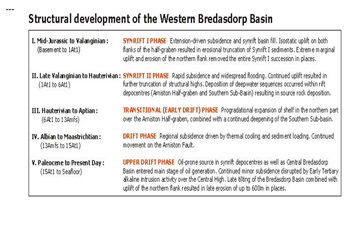
The pre-existing rift basins were dissected and subsided, and marine conditions prevailed thereafter. Bredasdorp basin stratigraphy is therefore divided into synrift and drift episodes of sedimentation.
Economic basement in the Bredasdorp basin consists of slates and quartzites of the Ordovician to Devonian Cape supergroup that are extensively faulted and fractured. The northern and southern flanks of the basin are bounded by the Infanta and Agulhas arches, respectively.
These features are elongate basement highs bounded by major fault scarps between which the synrift/drift depocenters were developed .
The Bredasdorp Jurassic-Cretaceous sediments directly overlie basement and fill a number of large southeasterly-trending half grabens. The succession is divided into two sequences separated by an angular type 1 unconformity-the drift-onset unconformity .
The graben-fill comprises a thick accumulation of alluvial fanglomerates and braided and meandering fluvial sediments that were deposited contemporaneously with faulting. Tuffaceous interbeds in this sequence indicate intermittent volcanic activity. The early graben fill is of Kimmeridgian or Portlandian age.
The first marine sandstones occur within the synrift succession, where they are interbedded with lagoonal and fluvial claystones. A thick marginal marine sandstone complex caps the sequence. This complex is well known from boreholes on the flanks of the basin and is an extensive regressive coastal barrier bar system of early Cretaceous age.
These sandstones form the major gas reservoirs of the north flank gasfields where the F-A gas field is currently being developed. The rift fill is truncated by the rift/drift unconformity , which is most erosive on the basin flanks. The synrift succession is intensively faulted and folded in places.
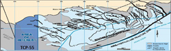
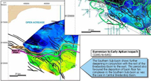
The drift sequence, deposited after the major rift/drift unconformity is characterized by deep-marine poorly-oxygenated conditions. The early drift succession from seismic horizons is an onlap, infill succession of deep marine claystones and sandy turbidites of Hauterivian to Barremian age .
Gas prone source rocks occur in some north flank wells and are expected to be present in the center of the basin but have not been intersected.
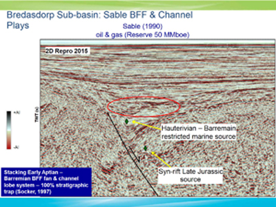
Barremian to mid-Aptian sedimentation was characterized by strong shelf progradation from the northern margin of the basin. Marine claystones are interbedded with shelf shoal sandstones around the northern rim and with deep marine fan lobe and channel sandstones in the central basin,During the Barremian low sedimentation rates resulted in the deposition of dry to wet gas prone and locally oil prone organic rich shales in the sequences that sourced gas accumulations in the basin .
The mid-Aptian unconformity was followed by a period of sediment starvation over much of the basin during which time organic rich shales were deposited in the central basin area. These wet gas and oil prone shales are the thickest and best quality source rocks in the Bredasdorp basin .
The late Aptian to Cenomanian sequences below sequence show strong progradation from the northwestern rim of the basin. In the northwest, shelf sandstones are interbedded with marine claystone while submarine fanlobe/channel sandstone development occurs, especially in the sequence in the central basin area.
During late Albian to Coniacian, another episode of sediment starvation occurred that resulted in the development of a further organic rich shale interval, but this is thin and mostly immature.
Late Cretaceous and Tertiary sediments are of shelf origin and are generally interbedded calcareous sandstones and marine claystones. By the end of Cretaceous, open shelf conditions prevailed over the entire Bredasdorp basin. Equivalent deepwater sediments are present to the southeast in the Southern Outeniqua basin .
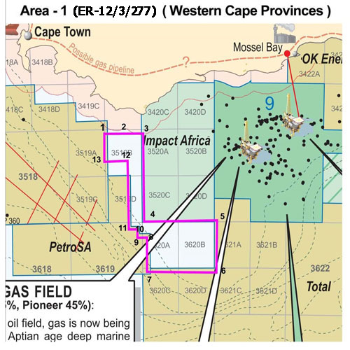
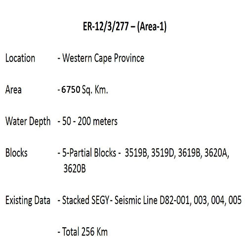
TCP-55 (ER-12/3/277)
Area of interest is southern continution of the West Bredasdrop basin
The Western and south western Extent of bredasdorp Basin has Significant Hydrocarbon potential. Favourable Oil and wet Gas prone source rock and reservoir occur in this area.
Several Basin Floor fan are associated with in this area.
Risk Perception
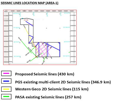
There is very limited seismic data only 5 lines (256 LKM) which are sparsely distributed in the block.
Therefore, risk perceived at this time can be mitigated through acquisition of more closely spaced seismic data and integration of seismic with offset well data, basin modelling, and Sequence Stratigraphy to generate leads & high grade prospects.
Resource Summary
Due to limited geoscientific data (especially seismic), resources within the Exploration Area-1 have not been estimated in specific with respect to prospect/ lead.
However, huge oil & gas resources are present in the vicinity of this block.
Source Rock Study
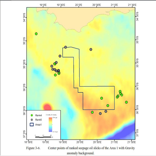
Aptian anoxic source rocks: Available evidence from drilling results suggests that the oil-prone nature of this source rock improves with increasing distance from the shore as one moves away from the diluting effect of the Orange River land-sourced sediment input. Furthermore, the thinning of the overburden to the west brings the Aptian succession into the oil window in the deeper water part of the basin towards the south. It is noteworthy that the thickness of overburden is not sufficient to have resulted in gas generation.
In the southern portion of the west coast (old Blocks 5 and 6), there is a good possibility that Hauterivian (and possibly lacustrine synrift source rocks of Valanginian age and older) source rocks may occur, similar to the satuation in Block-9.
Cenomanian/Turonian anoxic source rocks: Another possible source rock active in this part of the basin is considered likely to be present because of a worldwide anoxic event (or nutrient upwelling) that occured in the Cenomanian to Turonian of the late Cretaceous. Wells drilled off South Africa's south coast, off Namibia and off South America provide encouragement for the existence of this source sequence. Modelling shows that this postulated source has been mature for oil generation in the nothern part of the basin since the late Cretaceous.
In the deep water section of the basin the existence of numerous prospective plays throughout the stratgraphic section is indicated by vintage seismic data which consists of low fold, unmigrated academic seismic data and the new PGS non-exclusive survey, Geological modeling proposes that sand supply during the Cretaceous was ample, and several possible feeder canyons have been indentified on seismic data closer to shore that could have supplied sand to the slope and deeper basin.
Petroleum System Elements
The block Exploration Area-1 falls in the West Bredasdorp basin which has very high prospectivity.
Several major hydrocarbon discoveries have taken place in the near proximity of this block. All elements of the petroleum system are likely to be present.
SOURCE ROCK – Aptian Anoxic (mature, oil–prone) in the north,
Lacustrine syn-rift (Valanginian & older) in the south.
Cenomanian / Turonian Anoxic (mature, oil–prone) in the north,
RESERVOIR – Alluvial fanglomerates and braided and meandering fluvial sediments synrift marine sandstones, inter-bedded with lagoonal and fluvial claystones. (Rift and Drift)
SEAL – Predominantly Albian / Aptian basin Floor Fan (Drift Succession)
PLAY TYPE – Basin floor fans, turbidite channels, slope truncations along the shelf.
Potential Leads
Five potential leads have been identified on the preliminary interpretation.
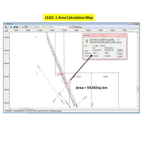
- LEAD-1- Turbiditic channel
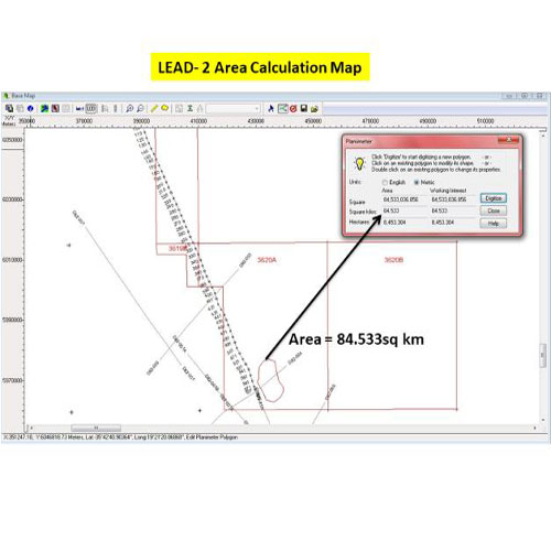
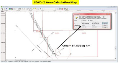
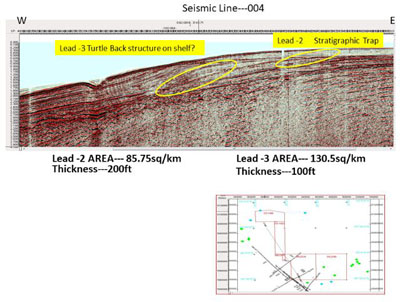
- LEAD-2- Turtle back structure on the shelf
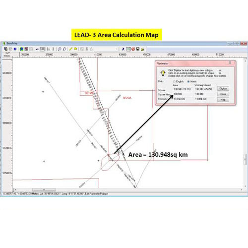
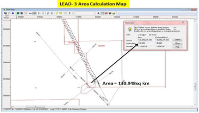
- LEAD-3- Canyon fill channel
- LEAD-4- Stratigraphic pinch out
- LEAD-5- Inverted structure
Summary Prospectivity
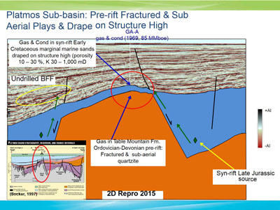
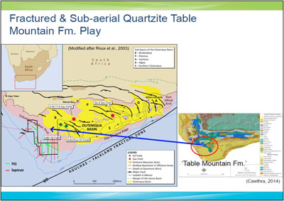
- Fractured & sub-aerial Quartzite Table Mountain Fm. play in the shallow pre-rift basement highs
- Large syn-rift structures: fault block rotation, roll-over anticline & Drape sands on structural high
- Large basin floor fan & channel plays with high aplitute supported by AVO analysis
Progress of Block Area-1 in year 2018
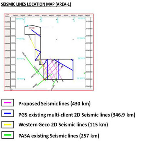
- SWE and PGS (UK) Exploration Ltd signed “Data Disclosure Agreement” to prospective joint venture for Multi-Client 2D seismic data (321.4 km) in Area-1 on 31st January 2017 prior to run new 2D seismic survey.
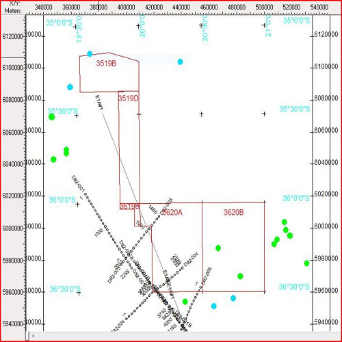
- Later SWE informed to contract with Western Geco to purchase their seismic line E1A#1 (117 km) which is crossing the existing PASA lines D82-003 and D82-004 inside Area-1 block.
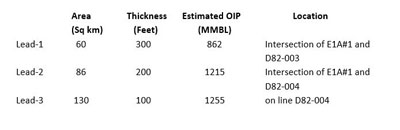
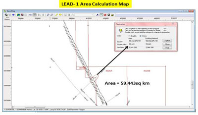
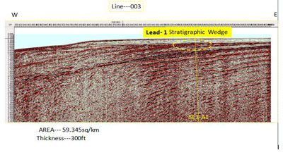
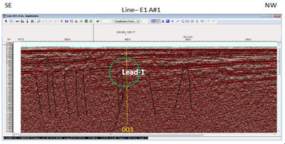
- After signing the Master License Agreement between SWE and Western Geco on 15th Feb. 2018, SWE technical team interpreted the resourced prospect area and gross thickness of Lead-1(60 sq. km & 300 feet) at the intersection of E1A#1 & D82-003 and Lead-2 (86 sq. km & 200 feet) and Lead-3 (130 sq. km & 100 feet) at the intersection of E1A#1 & D82-004.
- The resourced prospects of above lead 1, 2 and 3 are estimated as 862, 1215 and 1255 MMBL of oil respectively.
- In view to purchase PGS’s year 2014 Multi-Client 2D Seismic data (346.93 Km) for above resourced prospect study more confidently, SWE signed the General License and Supplemental Agreement with PGS (UK) Exploration Ltd on 5th April 2018.
- Now SWE planned for new 2D seismic acquisition (430km).